Skip to content
AV ScannerNews
FeedMapAreasScanner Codes
Submit a Tip
LIVE0 posts today · Latest: Fire on 90th Street East between Avenue L and Avenue K just…Synced 13m ago
AV Scanner News

Antelope Valley's source for real-time incident tracking, scanner codes, and community news.

admin@avscannernews.com
Get the app
Download on theApp StoreGET IT ONGoogle Play

Categories

  • Crime
  • Accident
  • Community
  • Missing Person
  • Fire
  • Traffic
  • Weather
  • General

Quick Links

  • Contact Us
  • Latest Posts
  • Scanner Codes
Lancaster Sheriff Station(661) 948-8466Palmdale Sheriff Station(661) 272-2400City of Lancaster(661) 723-6000City of Palmdale(661) 267-5100CHP After Hours(323) 259-3200CHP AV(661) 743-6060

© 2026 AV Scanner News. All rights reserved.

PrivacyTermsBuilt by Kernforge
FeedMapCodesTip
← BACK TO FEED
Weather

Eastern Antelope Valley Foothills SEVERE Red Flag Warning Wed, Aug 20, 2025 at 9:00 AM PDT — RED FLAG WARNING REMAINS IN EFFECT FROM 9 AM PDT WEDNESDAY…

Thu, Aug 21, 2025 · 10:38 AMNO LOCATION EXTRACTED
Eastern Antelope Valley Foothills SEVERE Red Flag Warning Wed, Aug 20, 2025...
Dispatch TextPARSED · 12 SEGMENTS
01

Eastern Antelope Valley Foothills SEVERE Red Flag Warning Wed, Aug 20, 2025 at 9:00 AM PDT

02

RED FLAG WARNING REMAINS IN EFFECT FROM 9 AM PDT WEDNESDAY TO 9 PM PDT SATURDAY FOR AN UNSEASONABLY HOT AND UNSTABLE AIR MASS CAPABLE OF PRODUCING EXTREME FIRE BEHAVIOR FROM VERTICAL PLUME GROWTH

03

LOW RELATIVE HUMIDITY

04

AND LOCALLY BREEZY WINDS FOR PORTIONS OF THE MOUNTAINS AND FOOTHILLS OF LOS ANGELES AND VENTURA COUNTIES

05

 * TEMPERATURES

06

Unseasonably hot high temperatures, generally 95- 110 degrees and highest Thursday through Saturday, producing unseasonably unstable conditions. * RELATIVE HUMIDITY

07

Minimum relative humidity 8-20 percent, lowest Wednesday and Thursday. * THUNDERSTORMS

08

Isolated thunderstorms will be possible Friday through the weekend, and any accompanying lightning strikes will be capable of starting new fires on the peripheries of rain cores. * WINDS

09

Southwest at 10-20 mph gusting to 20-25 mph over the western Antelope Valley Foothills and vicinity and in other wind- favored areas such as through passes and canyons. Lighter winds elsewhere. Passing outflow boundaries could bring sudden wind- shifts and increased fire-spread rates, even from distant thunderstorms. * IMPACTS

10

If fire ignition occurs, conditions are favorable for extreme fire behavior and rapid fire growth, which could threaten life and property. Be aware of sudden re-direction of fires in response to passing outflow boundaries. * ADDITIONAL DETAILS

11

Fire-weather headlines may eventually need to be extended into Sunday. PRECAUTIONARY/PREPAREDNESS ACTIONS

12

A Red Flag Warning means that fire-weather conditions are expected to be favorable for the development of extreme fire behavior. Use extreme caution with anything that can spark a wildfire. Residents near wildland interfaces should be prepared to evacuate if a wildfire breaks out. See readyforwildfire.org and wildfirerisk.org for information.
VIEW RAW SCANNER TEXT

Eastern Antelope Valley Foothills SEVERE Red Flag Warning Wed, Aug 20, 2025 at 9:00 AM PDT ...RED FLAG WARNING REMAINS IN EFFECT FROM 9 AM PDT WEDNESDAY TO 9 PM PDT SATURDAY FOR AN UNSEASONABLY HOT AND UNSTABLE AIR MASS CAPABLE OF PRODUCING EXTREME FIRE BEHAVIOR FROM VERTICAL PLUME GROWTH...LOW RELATIVE HUMIDITY...AND LOCALLY BREEZY WINDS FOR PORTIONS OF THE MOUNTAINS AND FOOTHILLS OF LOS ANGELES AND VENTURA COUNTIES...  * TEMPERATURES...Unseasonably hot high temperatures, generally 95- 110 degrees and highest Thursday through Saturday, producing unseasonably unstable conditions. * RELATIVE HUMIDITY...Minimum relative humidity 8-20 percent, lowest Wednesday and Thursday. * THUNDERSTORMS...Isolated thunderstorms will be possible Friday through the weekend, and any accompanying lightning strikes will be capable of starting new fires on the peripheries of rain cores. * WINDS...Southwest at 10-20 mph gusting to 20-25 mph over the western Antelope Valley Foothills and vicinity and in other wind- favored areas such as through passes and canyons. Lighter winds elsewhere. Passing outflow boundaries could bring sudden wind- shifts and increased fire-spread rates, even from distant thunderstorms. * IMPACTS...If fire ignition occurs, conditions are favorable for extreme fire behavior and rapid fire growth, which could threaten life and property. Be aware of sudden re-direction of fires in response to passing outflow boundaries. * ADDITIONAL DETAILS...Fire-weather headlines may eventually need to be extended into Sunday. PRECAUTIONARY/PREPAREDNESS ACTIONS... A Red Flag Warning means that fire-weather conditions are expected to be favorable for the development of extreme fire behavior. Use extreme caution with anything that can spark a wildfire. Residents near wildland interfaces should be prepared to evacuate if a wildfire breaks out. See readyforwildfire.org and wildfirerisk.org for information.
More in Weather
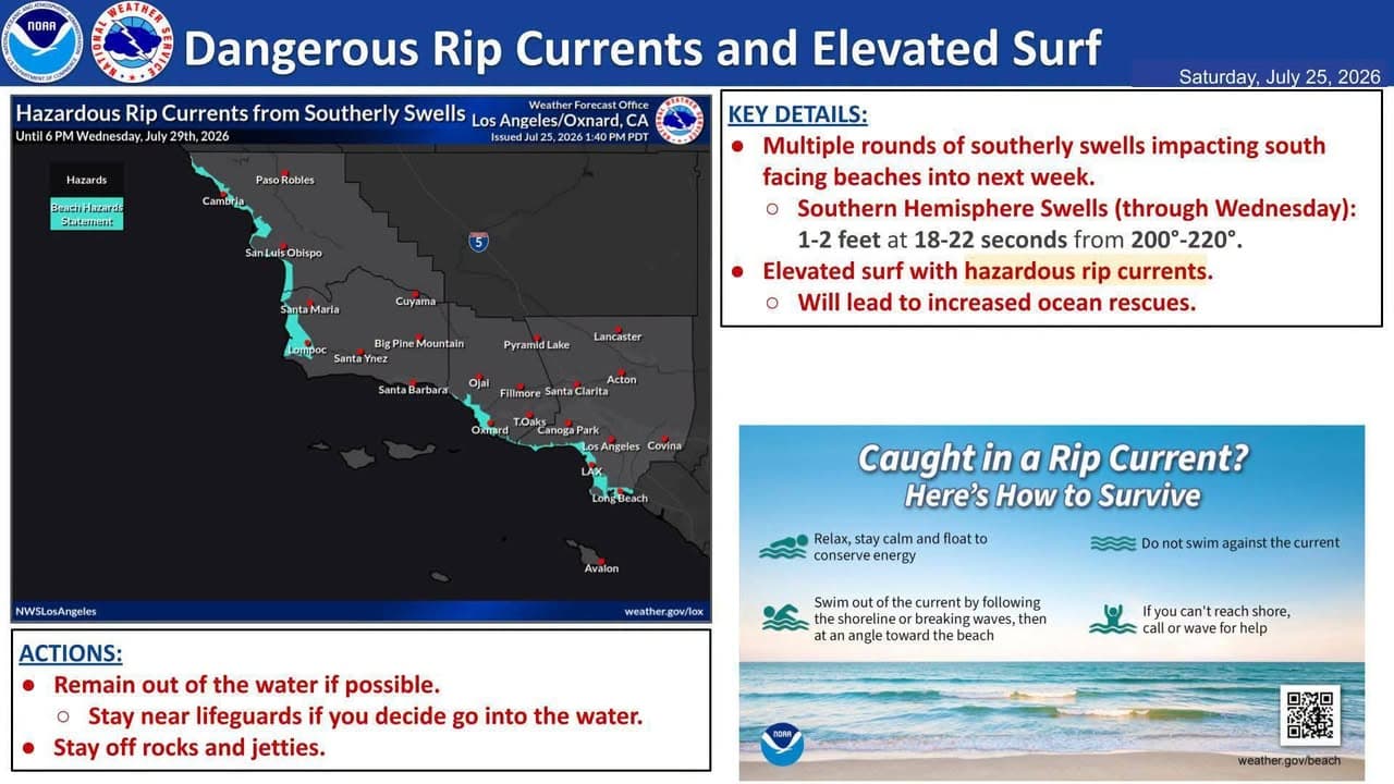
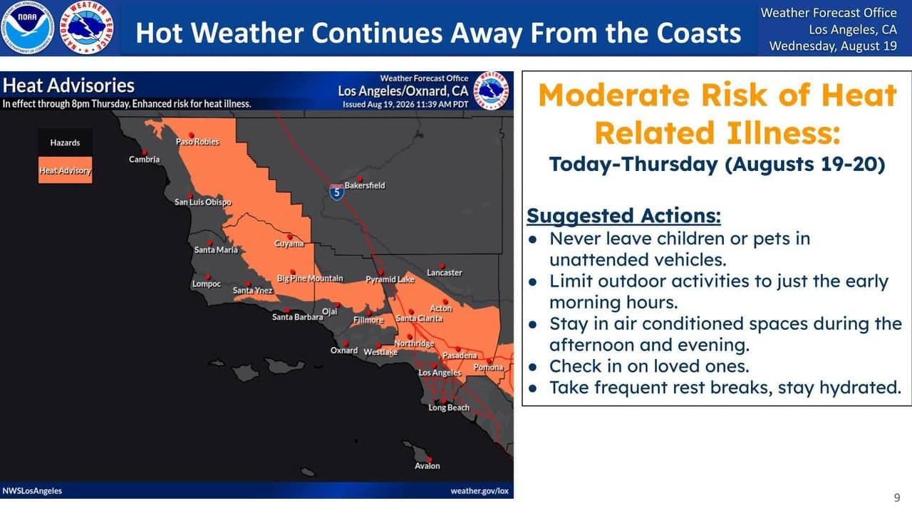
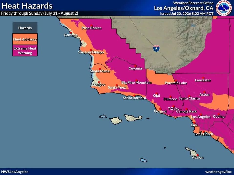
2:59 PM7d agoWeatherHere are the highest temperatures forecast for Southwest California Friday through Sunday.……Heat Advisories and Extreme Heat Warnings are in effect for most the area during this time. Use extra caution to stay safe in the heat! Stay hydrated, check on others and NEVER leave kids or pets in a parked car! Outdoor workers take rest breaks in the shade. Provide shade and water for outdoor animals5:08 PM12d agoWeatherWell, Summer heat will continue to be the main story this weekend……and throughout next week for Southwestern California. Today through Monday, moderate to high heat risk is expected for most areas and Heat Advisories are in effect for most areas and even a Extreme Heat Warning for the Antelope Valley. There will be a "slight" break in the heat on Tuesday and Wednesday. However, even more intense heat is possible the second half of next week into next weekend. So, please exercise caution in this heat. Stay well hydrated, limit outdoor activities during the peak heating of the day and check on sensitive family members and neighbors. If you are looking to go to the beach to "beat the heat," please be very cautious. A combination of swells from Hurricane Fausto, as well as the Southern Hemisphere, will generate elevated surf across south and southwest-facing beaches as well as very strong and dangerous rip currents. Make sure to follow directions from local lifeguards at the beaches. Finally, there will be an elevated to brief critical fire weather risk for the area due to the combination of the heat, low humidity, gusty winds and dry fuels. Any grass fires will spread very quickly. Deep mixing heights (10000-16000 feet) will bring the potential for significant, plume-dominated, fire behavior. So, be careful with any ignition source and have a plan if a wildfire breaks out near you. Try to stay cool out there, Southern California, and have a great weekend!!!!!!!!!!!!!!!!!6:55 PM16d agoWeatherAn extended period of high temperatures is expected this coming week, hottest……Thursday through next Monday. Interior highs will be 98-108 with warm overnight lows. Heat Advisories are in effect for most areas away from the immediate coast, with an Extreme Heat Warning for the Antelope Valley. Use extra caution during this time, check on others and remember: never leave kids or pets in a parked car. Also not a great time to hike with your dog!
SourceView original post on Facebook
PostedAug 21, 10:38 AMImportedMar 22, 7:17 AMCategoriesAuto · WeatherLocationNot extracted