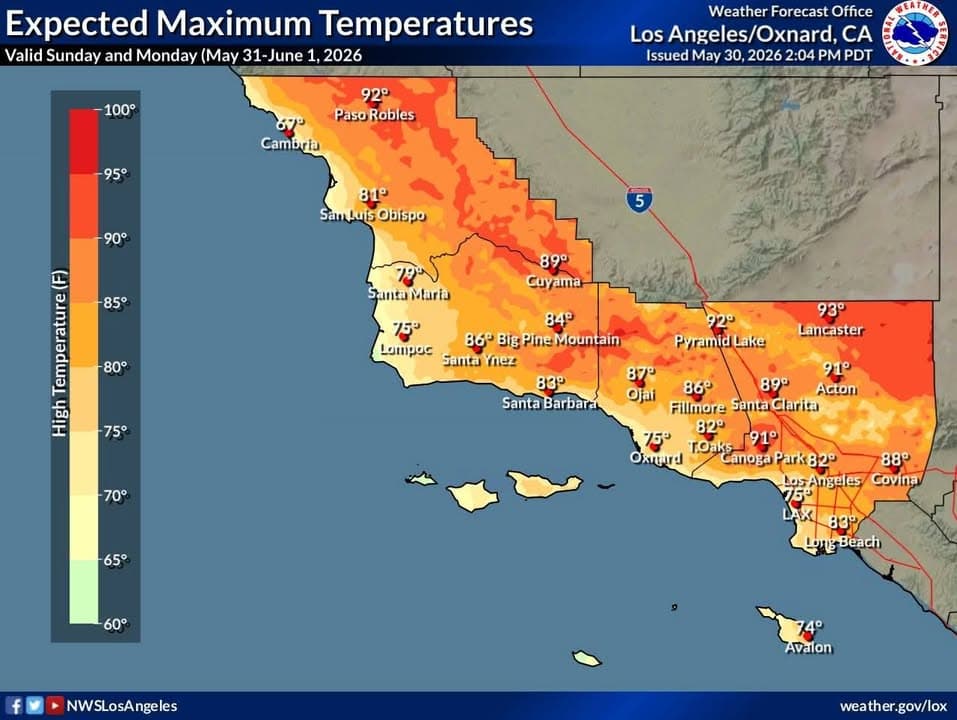
From the National Weather Service
Effective: 2025-08-24 12:25:00 PDT
Expires: 2025-08-24 13:15:00 PDT
Urgency: Expected
Severity: Moderate
Certainty: Observed
Instruction: If outdoors, consider seeking shelter inside a building. Frequent cloud to ground lightning is occurring with this storm. Lightning can strike 10 miles away from a thunderstorm. Seek a safe shelter inside a building or vehicle. Persons in campgrounds should consider seeking sturdy shelter until this storm passes.
Target Area: Western San Gabriel Mountains and Highway 14 Corridor; Eastern San Gabriel Mountains; Western Antelope Valley Foothills; Eastern Antelope Valley Foothills; Antelope Valley
At 1221 PM PDT, Doppler radar was tracking a strong thunderstorm near Pearblossom AND Littlerock, approaching Highway 138. This storm was drifting slowly northward at 5 to 10 mph.
HAZARD...Wind gusts up to 50 mph and pea size hail. Some dry lightning strikes likely.
SOURCE...Radar indicated.
IMPACT...Gusty winds could knock down tree limbs and blow around unsecured objects. Minor hail damage to vegetation is possible. Dry lightning strikes on periphery of storm could cause new fire ignitions.
Locations impacted include... Palmdale... Pearblossom... Llano... Littlerock... Valyermo... and Highway 138..