Skip to content
AV Scanner News
Codes
AllCrimeAccidentCommunityMissing PersonFireTrafficWeatherGeneral
AV Scanner News

Antelope Valley's source for real-time incident tracking, scanner codes, and community news.

admin@avscannernews.com
Get the iPhone appDownload on theApp Store

Categories

  • Crime
  • Accident
  • Community
  • Missing Person
  • Fire
  • Traffic
  • Weather
  • General

Quick Links

  • Contact Us
  • Latest Posts
  • Scanner Codes
Lancaster Sheriff Station(661) 948-8466Palmdale Sheriff Station(661) 272-2400City of Lancaster(661) 723-6000City of Palmdale(661) 267-5100CHP After Hours(323) 259-3200CHP AV(661) 743-6060

© 2026 AV Scanner News. All rights reserved.

PrivacyTermsBuilt by Kernforge
  1. Home
  2. Weather
  3. Well through Monday, it's looking warm and dry across Southwestern California. Afternoon...
Saturday, May 30, 2026 at 2:57 PM

Well through Monday, it's looking warm and dry across Southwestern California. Afternoon...

Weather
Well through Monday, it's looking warm and dry across Southwestern California. Afternoon...

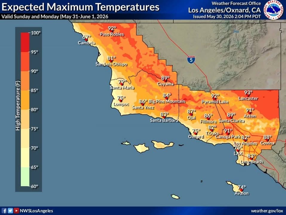
Well through Monday, it's looking warm and dry across Southwestern California. Afternoon temperatures on Sunday and Monday are expected to top out in the 70s along the coast, but the 80s to lower 90s across the valleys and interior sections. Temperatures will be 5-10 degrees above seasonal normals. At this time, no significant heat risk issues are expected.

As the temperatures rise, breezy and dry conditions will develop acorss the area. Tonight through Sunday night, southwest to northwest winds, gusting 30-50 MPH, can be expected across the Central Coast, Santa Ynez Mountains, I-5 Corridor and the Antelope Valley. With minimum relative humidtiy dropping into the 10-25% range away from the coast, there will be an elevated fire weather risk with an enhanced potential for grass and brush fires.

For Tuesday through the rest of next week, there will be some slight cooling west of the mountains, but some warming across interior sections. An elevated risk of grass and brush fires will continue across interior sections with gusty onshore winds and continued low relative humidity.
Related Incidents

High Fire Weather Risk Wednesday through Thursday. Stay alert. Listen to advice...
Jul 14, 2026 · 3:07 PM

High Fire Weather Risk Wednesday through Thursday. Stay alert. Listen to advice...

High Fire Weather Risk Wednesday through Thursday. Stay alert. Listen to advice from emergency officials. Be careful with anything that can spark a fire...

Read more
🌡️Warm temperatures are here to stay!! 🌞 Heat Advisories are in effect...
Jul 8, 2026 · 3:53 PM

🌡️Warm temperatures are here to stay!! 🌞 Heat Advisories are in effect...

🌡️Warm temperatures are here to stay!! 🌞 Heat Advisories are in effect today into next Tuesday for many areas away from the coast, followed by a widespread Extreme Heat Watch...

Read more
Forecast for Independence Day Holiday: Temperatures will be near or slightly below...
Jul 3, 2026 · 2:42 PM

Forecast for Independence Day Holiday: Temperatures will be near or slightly below...

Forecast for Independence Day Holiday: Temperatures will be near or slightly below normal. High clouds are expected during the day, then low clouds are likely in the evening for portions...

Read more